

Acum urmărești pe
A apărut o eroare la urmărirea utilizatorului.
Utilizatorul nu le permite altor utilizatori să-l urmărească.
Urmărești deja acest utilizator.
Planul tău de abonament permite doar 0 urmăriri. Alege un abonament superior apăsând aici .
Nu mai urmărești pe
A apărut o eroare la anularea urmăririi utilizatorului.
Ai recomandat pe
A apărut o eroare la recomandarea utilizatorului.
A apărut o eroare. Reîncarcă pagina și încearcă din nou.
Adresa de e-mail a fost confirmată.

acarigua,
venezuela
Momentan, aici e ora 12:17 a.m.
S-a înregistrat pe martie 15, 2022
1
Recomandare
Daniel L.
@Danlp81
4,8
4,8
85%
85%
acarigua,
venezuela
93 %
Proiecte finalizate
100 %
Conform bugetului
100 %
La timp
13 %
Rata de angajare repetată
GIS Expert - Civil Engineer and Spatial Analysis
Discută cu Daniel L. despre proiect
Conectează-te pentru a discuta pe chat despre detalii.
Portfoliu
Portfoliu

CAD data integration in ArcGIS Pro and 3D modeling
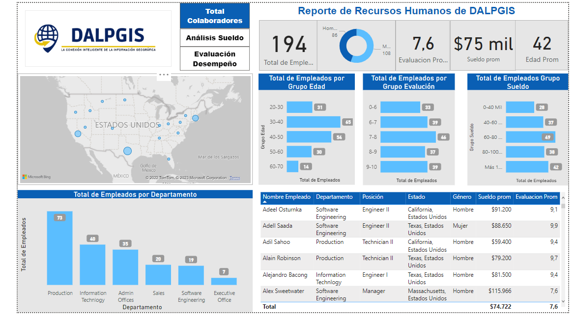

Dashboard with Power Bi

Dashboard with Power Bi

Dashboard with Power Bi

Dashboard with Power Bi

Dashboard with Power Bi

Dashboard with Power Bi
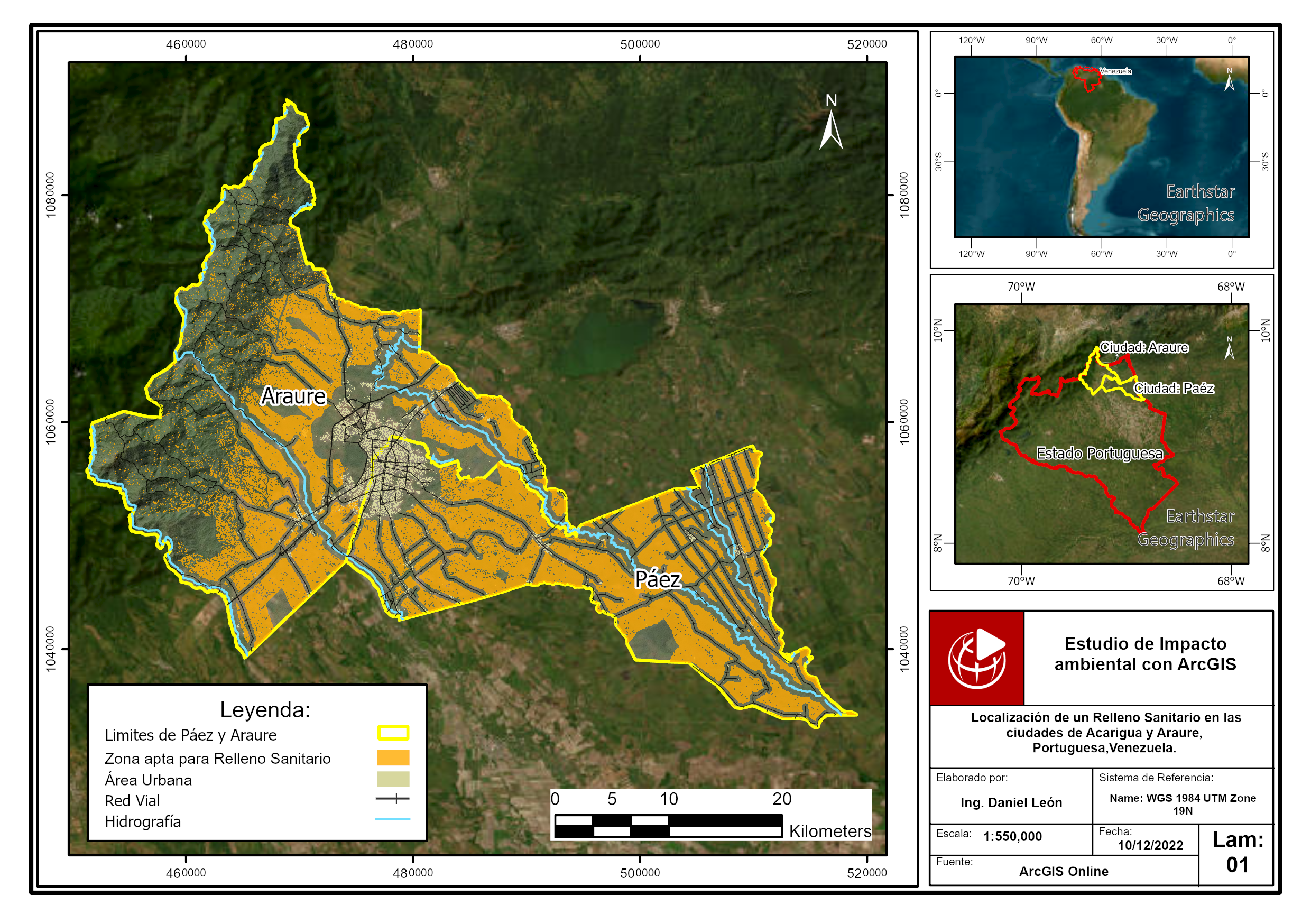

Location of a sanitary landfill through multicriteria analys

Location of a sanitary landfill through multicriteria analys
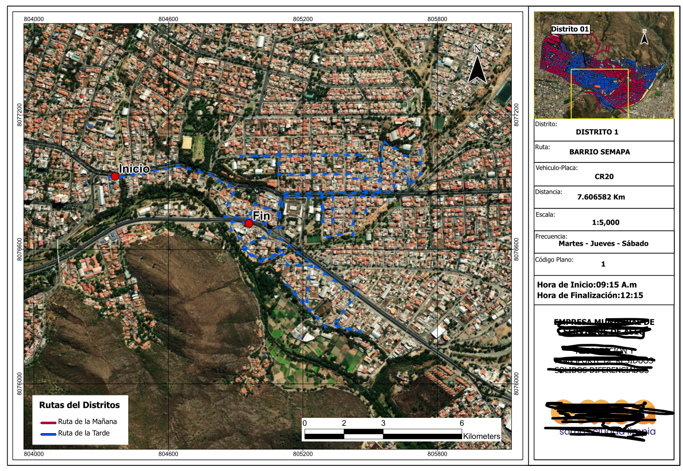

Series of maps to plan cleaning routes
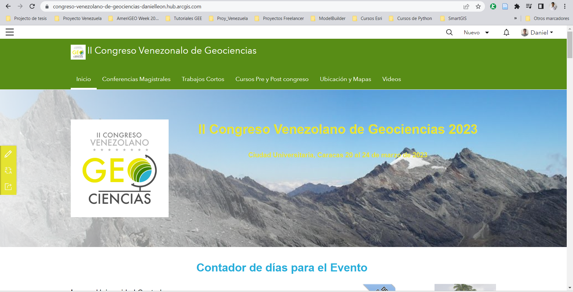

Web solution for events with ArcGIS

Web solution for events with ArcGIS

Web solution for events with ArcGIS

Web solution for events with ArcGIS
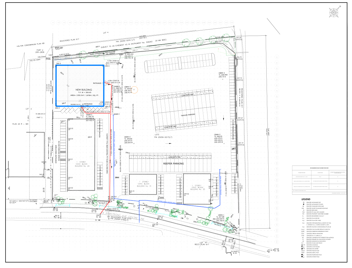

Site plan design for construction projects

Site plan design for construction projects

Site plan design for construction projects

Site plan design for construction projects

Site plan design for construction projects

Site plan design for construction projects
CAD data integration in ArcGIS Pro and 3D modeling
Dashboard with Power Bi
Dashboard with Power Bi
Dashboard with Power Bi
Dashboard with Power Bi
Dashboard with Power Bi
Dashboard with Power Bi
Location of a sanitary landfill through multicriteria analys
Location of a sanitary landfill through multicriteria analys
Series of maps to plan cleaning routes
Web solution for events with ArcGIS
Web solution for events with ArcGIS
Web solution for events with ArcGIS
Web solution for events with ArcGIS
Site plan design for construction projects
Site plan design for construction projects
Site plan design for construction projects
Site plan design for construction projects
Site plan design for construction projects
Site plan design for construction projects
Recenzii
Modificările au fost salvate
Se afișează 1 – 5 din 9 recenzii
€100,00 EUR
Data Processing
Excel
Cartography & Maps
Geospatial
+ încă 1

•
$500,00 USD

•
€50,00 EUR
Data Processing
Excel
Cartography & Maps
Geospatial
+ încă 1
•
$200,00 USD
Excel
SPSS Statistics
ArcGIS
A
•
$200,00 USD
Data Processing
Excel
Cartography & Maps
Geospatial
+ încă 1
S

•
Experiență
Applied Science Research Assistant
sept. 2021 - Prezent
Project Manager of Exposure and Seismic Vulnerability of Buildings Using Multispectral and UAV Imaging in Chosica, Peru.
Communications committee leader for AmeriGEO Week 2022.
Co-author of the "Manka Watikay" Project, where an analysis of the exposure of the Ollas Comunes to different types of threats was carried out.
Technical and logistical support with multidisciplinary representatives in international organizations and governments.
Educație
Technician in Topography
(2 ani)
Civil Engineer
(6 ani)
Discută cu Daniel L. despre proiect
Conectează-te pentru a discuta pe chat despre detalii.
Verificări
Cele mai bune aptitudini
Caută freelanceri similari
Caută prezentări similare
Invitația a fost trimisă!
Mulțumim! Ți-am trimis prin e-mail linkul pe care trebuie să-l accesezi pentru a revendica creditul gratuit.
A apărut o eroare la trimiterea e-mailului. Încearcă din nou.
Nu s-a putut efectua copierea în clipboard. Încearcă din nou după ce-ți ajustezi permisiunile.
S-a copiat în clipboard.
Se încarcă previzualizarea
S-a oferit permisiunea de depistare a locației.
Ți-a expirat sesiunea pentru conectare sau te-ai deconectat. Conectează-te din nou.